› Forums › 2005 Flags on the 48 › 2005 Trip Reports › Carrigain
-
AuthorPosts
-
I awoke earlier than expected at the Broken Branch KOA, which turned out to be a good thing. I broke camp, hit the showers to change and headed out for the Signal Ridge trailhead. I had no idea when I left how far away it was from the campsite. Luckily MichaelJ had given me great directions to get there. However, I arrived 15 minutes later than my planned 7am departure. Michael had reminded me that Hockeycrew offered to help, as my hip had been bothering me. So, assuming they were already ahead of me, I got my act together and hit the trail at 7:25.
Having dutifully read my WMG, I knew that the first half of the 5 miles were relatively flat, so I tooled across as fast as I can. When I hit the water crossings, I saw boot prints on the rocks, which indicated the other hikers weren’t too far ahead. I kicked into gear and quickly made it to the true ascent.
I ran into a group of guys coming down, and they asked what the pole was for. They fell kinda silent for a moment, then one said “Thank you for that. My father-in-law went through 9-11. So I mean that, thank you.” What a boost!
Here I stopped to zip the legs off of my pants, and was passed by a Forest Ranger. She discussed how she pulls all sorts of junk off the peaks, but a lot of flags. I told her that we let everyone know to practice LNT, and I would hope she doesn’t have to pull any of ours down. She continued on as I finished changing and hit the climb.
I was doing good for a while, then I hit the 1-mile straight climb up the side of the ridge. This was work for my first hike of the year. At one point, I measured my heart rate at 160. I realized I was probably pushing harder than I should have… and took a few more regular breaks.
I was grateful to see the left hand turn to get me off that maddening stretch. Climbing rocks is one thing. But to do it constantly with no change really drained my energy. I hit a swithcback that appeared you could turn right or left. Someone passed me and said “We go right”. This is an interesting place if you’ve happened to read Hockeycrew’s report. 🙂
As I approached the ridge, another group of hikers caught me, two older gentlemen and a young boy. One of them told me he was BigJim and that he was finishing his 48 that day. The boy was on his 29th I believe. We made it over the ridge together, and enjoyed the views. However, I was on a mission, and needed to keep moving to the peak proper.
I dipped into the col and started climbing the cone of Carrigain. Quite a steep section, and my quads were just about shot at this point. The guys caught up to me and passed me within 100 feet of the top. I finally broke out into the clearing and alighted the few steps up the tower. I never had a staircase hurt so much! 🙂
I started setting up a flag, and BigJim asked if he could set up his flag as well. He had brought a flag that was on his grandfather’s casket, a WWII vet. I said I would be honored, and he draped his over the north side of the tower, while my pole was in the southern corner.
Shortly after putting up the flag, Hockeycrew and her team arrived with their flag. I guess they weren’t ahead of me after all! I looked at my watch and realized that I had flown up the mountain in 4:20, just 10 minutes over book time! They set their flag up and proceeded to indulge in an M&M map. 😉
Surprisingly there were not a lot of visitors to the tower while we were there. At least, not compared to the crowds of say, Liberty, my last peak that I covered. But we had a good time chatting with some of the couples who came by.
I borrowed some binoculars and took a look at some of the other peaks. But it was difficult to see through the haze that day. Never saw or heard the A-10s buzzing around.
2pm came, and our break was over. I took the flag down adn started down the trail. I was frustrated by the loose rock on the trail. Everytime i tried to get into a rhythm, i’d take two steps and my foot would slide out from under me on a loose rock. I resigned myself to a slow descent. A few times I rolled my ankle, with pain dupicating in my hip. My only hope was to make it to the flat section.
Once I did, I set a strong rhythm and tooled right out of there. I’d had enough of the trail that day. OR rather, my calves and quads had had enough. Surprisingly, my back and knees were fine. Maybe I’m finally packing the right amount. 💡
I made it off the trail, attended to the blister, and made my way to the Mooseland. Because of the travel, no beer tonight. But wait’ll next year!
#13 – Carrigain.
-Stephen
Excellent! I knew you could make it!
One of the best in all the Whites! Signal Ridge is not too shabby either.
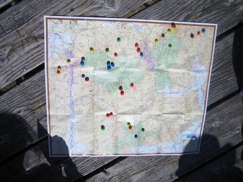
I like the idea of an edible map!!
What were the M&M’s marking… other peaks?
Really funny picture.
dirt_girl
The M&M represent the 4000fters that I have already done. On that side of the map I think the only ones I hadn’t completed were Galehead, Owl’s Head and Moosilauke.
After I finished my map (and each of those is half an M&M the other half being in my tummy), my friend Laurel, who has done much less peaks than me, ate the summits she had not completed yet, leaving maybe a half-dozen M&Ms in the general pemigewasset, willey range section of the map.
So the key here is to hike with someone who has done more summits, because that means more M&M’s 😀
Damn, having finished my 67 that’s going to be tough…
Hockeycrew and Laurel, you must have been a riot to hike with!!
😀 :flag: 😀 :flag: 😀 :flag:Thanks for the explaination, which only served to make the whole thing just a bit funnier!!
Hiking is all about the justifiable quanities of chocolate!!!
:spin:
-
AuthorPosts
- The forum ‘2005 Trip Reports’ is closed to new topics and replies.