› Forums › 2011 Flags on the 48 › 2011 Trip Reports › Middle Carter Mountain
-
AuthorPosts
-
#48051 |
The crew for this hike were: Kenneth Guerin, Claire Werbicki, Gary Braxten, Peter Willey, Chuck Hacala and Joey Tang.
Maps:
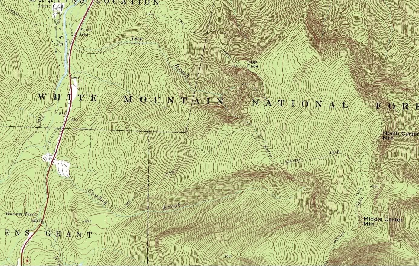
Area Road Map showing Bartlett and surrounding towns
Trail MapBeing the 10th anniversary of the 9/11 terrorist attack, this year’s peak sign-up for the FOT48 hike was a feeding frenzy. In the months leading up to July’s sign-up date, I had planned on choosing Mount Monroe, a 5000’er in the shadow of Mount Washington. However, with a possible newbie joining the crew, I didn’t want to tackle a peak above treeline. So I opted to try for Mount Carrigain. In the end, it didn’t matter. I wasn’t fast enough filling out the sign-up form and my first, second, third, fourth and fifth choices were already taken in the first 4 or so minutes it took to cycle through my choices. In the end, it was to be Middle Carter Mountain, a 4610′ mountain with a treed summit and a 5 mile hike away.
Being my Plan F selection, I was not looking forward to this hike. It seems that I alternate between the peaks I want and the peaks I get stuck with. Passaconaway, which I did two years ago, also had a treed summit after a long hike in and it was not an enjoyable experience. The difference this time, however, was that the weather was much, much better. Even so, the weather had already taken its toll before we even arrived at the trailhead.
With Sunday being the anniversary of the 9/11 attack, the hike took place on Sunday instead of the usual Saturday. My friend Gary was able to get us some bunk space at the Penguins Ski Club in Bartlett and Claire and I met my other friends and co-workers up there on Saturday afternoon. The drive up was longer than usual, because storm damage from Hurricane Irene had wrecked portions of the Kancamagus Highway, which leads from I-93 to Bartlett via Bear Notch Road. So, we had to take the much longer NH25 route to North Conway and backtrack a bit.
After Chuck and Joey arrived at the Penguins in Chuck’s car, we drove down to the Moat Mountain Smokehouse and Brewery in North Conway for some truly outstanding food and beers. After dinner, we went back to the ski club in the darkness of the autumnal evening and prepared our packs for the next day’s outing. Instead of cooking our own breakfast, we decided to go out to eat for breakfast, a decision that affected our timing for raising the flag.
The Glen Junction Family Restaurant wasn’t open ’til 7am and I knew that going there meant that our estimated start time of 7:30 wasn’t going to be met. As I was still fighting the last remnants of my cold, I decided that making the summit at 12 was not going to be a priority on this hike. We were going to do the best we can. In the end, it was good that I changed priorities because service in the restaurant was slow and we didn’t get back in our cars until 8am.
The original hiking route was to take the northern leg of the Imp Trail to the North Carter Trail to Carter-Moriah Trail to the summit. However, one of the members on the FOT48 forum notified me that the trailhead to the northern leg of the Imp Trail was closed due to storm damage. So we took the slightly longer, but less steep, southern leg.
We arrived at the southern trailhead of the Imp Trail at 8:30. Immediately, we knew that the conditions were not going to be good in spite of the excellent weather we had. A warning sign had been stapled to the trail sign notifying hikers that the trail had not been inspected for hurricane damage and may not be safe for recreational use. We were further advised that we might have to turn back.
In the end, we didn’t have to turn back, but there was heavy trail erosion. I’d never hiked this trail before, but in some spots the trail had become a trench 9-24″ deeper than the surrounding ground, and filled with rocks and sand and sediment. We saw evidence of numerous washouts filled with deadfall debris and streams had gouged new paths where silt and sediment had settled in the former stream bed. In one particular area, the washout had stripped the soil down to a yellow clay which contained a hollowed out core similar to a glacial pothole, formed by the swirling sand trapped in the water. While the effects were fascinating to behold, the constant travel over loose rocks and stones took a toll on all of our feet throughout the day.
The hike started with temps in the 40s in the shadow of the eastern mountains. Slowly, as the hike began to warm our bodies, sunlight began to peek over the ridge and filter through the leaves overhead, giving the light a greenish cast to it. Claire remarked that the strange light was playing havoc with her sight.
The bottom part of “South Imp”, had a very easy grade over packed dirt; the trail erosion that we were to encounter did not touch this section of trail much. It went southeast and then looped back northeast after about 1.5 miles. The rather large bend is due to a cliff face call The Imp. Both legs of the Imp Trail, climb up the rocky knob from both directions, making a horseshoe loop with Route 16.
When we turned northeast, the trail got quite a bit steeper, though not horribly so compared to other trails I’ve been on. However, Claire and I haven’t hiked together since May and I hadn’t hiked since my aborted attempt at Humphreys Peak in Arizona, and the downtime showed. We both started lagging behind the others, not by a lot, but enough. The remnants of my cold was also affecting my ability to breathe; I was mouth breathing the whole time and sniffling between breaths. Not fun, but not enough to keep me from continuing.
We took numerous breaks on the climb up to the junction with North Carter Trail, which was 3.2 miles from the trailhead. Finally, after what seemed an eternity, we got to the trail junction. From there, we had a 1.3 mile hike to the ridge.
North Carter Trail had taken a beating from Hurricane Irene. The trail was a constant climb up loose rock, gravel and sediment and had taken the brunt of the force of the rushing water of the storm. Claire and I lagged quite a bit behind the others here as well.
One more note about the trail conditions and weather needs mentioning as well. While the weather was dry and pleasant, the tree-sheltered trail still had a lot of moisture from the hurricane and from the 4 days of rain prior to our trip. All the rocks and roots we were climbing on were wet and every footfall carried a risk of slippage. With memories of the accident that befell our troupe last year, we were all a little careful.
By the time we hit the junction of the Carter-Moriah Trail, it was well past noon. This section of trail is part of the Appalachian Trail and it was here that we met our first through-hiker of the day. “DVD” was a woman who was hiking this part of the trail solo and had been hiking since March. She had left the Carter Notch AMC hut earlier that morning and had already hiked over Carter Dome (4832′), South Carter (4430′) and Middle Carter (4610′). She was on her way to hiking over North Carter Mountain, Imp Mountain and Mount Moriah (4049′). I figure that she’s about 3 weeks from completing her trek to Mount Katahdin.
The ridge hike to Middle Carter was only about 0.5 miles and it went by quickly. Surprisingly, the trail contained many viewpoints and exposed ledges to offer views over to the Presidentials to the west and into the state of Maine to the east. The air was drier now that we were out of the heavier trees and we all began to warm up and dry off.
We hit the summit at 1:15 and had the flag raised by 1:20, giving us a hiking time of 4:45. It was a long one, but once we got the flag up, we all relaxed. After raising the flag and settling in a bit, Claire took out her Tibetan prayer bowl and we all gathered by the flag for a moment of silence. Joining us were two other AT through-hikers. After a simple statement regarding our intentions, Claire used the striker on the bowl and, after a single note, got the bowl to sing, its strong vibrations surrounding us and lifting into the air beyond. The tone and vibrations lingered for a long time and at the end, the moment was over. It brought a spiritual, moving experience to our endeavor and allowed us to remember why we were there in the first place.
As treed summits go, Middle Carter was pretty nice. The trees were short and they did block the views, but one of the open ledgy viewpoints was close by and someone had created a 5-step footpath off the summit into the scrub trees, opening up an excellent view to the east.
At 2:15, we packed the flag and began our descent, which was long and painful. My feet were not happy with the countless rocks on the trail. Our group had two minor falls on the way down, but the only wounds were a couple of rock scrapes. After 3:45 of hiking, we reached our cars at 6:00.
After the hike, most of our crew had dinner at the Red Parka Restaurant and Pub, while two of our crew drove back home in the failing light. Luckily, the Kancamagus Highway had been reopened that day and they were able to shave an hour off of their driving time.
After spending a second night at the Penguins, Claire and I headed home in the morning, with a side trip to the White Mountain Cider Company for a couple of cider donuts and coffee. We also took the Kancamagus Highway and were able to see just how much damage the storm had caused and how quickly New Hampshire fixed the road. Both the damage and the repairs were nothing short of impressive.
All in all, it was a long day. Ten mile day trips are fairly long and I particularly felt the long hiatus from hiking. Difficulties aside though, the importance of what we were doing were expressed to us by a hiker who we met as he was descending from the ridge. Seeing our PVC poles and knowing about the Flags on the 48 hike, as a US veteran he expressed his gratitude to us for our commitment to the day and the memories of those whose lives were lost. For me, that made it all worthwhile.
-
AuthorPosts
- The forum ‘2011 Trip Reports’ is closed to new topics and replies.